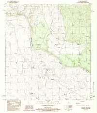
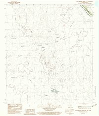
1983 Map of Salt Well
USGS Topo · Published 1983About this map
The Rio Grande Rio Bravo forms the international boundary in this arid borderland, where the terrain shifts from the flat alluvial plains of Maverick Co and Webb Co into the undulating hills of Coahuila. Settled life on the Texas side centers around the namesake Salt Well and the nearby Borrego Creek, while the Mexican landscape is punctuated by numerous named ranchos and topographical markers. The map captures a complex mix of jurisdictions, featuring an Indefinite Boundary and the convergence of state and county lines.
Find a feature on this map
18 named features on this map. Tap any name to fly to it.
Don’t see what you’re looking for? This feature index may not catch every label — zoom into the map to look around manually.
Map Details
Editions of this 1983 Salt Well Map
This is the sole edition of this map. No revisions or reprints were ever made.
Other maps of this area

1940 · Chupadera
USGS Topo · 1:62,500

1941 · Botella Creek
USGS Topo · 1:62,500

1957 · Indio Creek
USGS Topo · 1:62,500

1957 · Botella Creek
USGS Topo · 1:62,500

1958 · Eagle Pass
USGS Topo · 1:250,000

1965 · Eagle Pass
USGS Topo · 1:250,000
1982 · Tovar Creek East
USGS Topo · 1:24,000
1982 · San Pedro Creek
USGS Topo · 1:24,000
1983 · Tovar Creek West
USGS Topo · 1:24,000
1983 · San Ambrosia Creek 3 NE
USGS Topo · 1:24,000