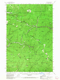
1956 Map of Saltese
USGS Topo · Published 1967About this map
St Joe National Forest and the Coeur d'Alene National Forest meet at the Idaho-Montana border, a landscape defined by its deep mining history and vital transcontinental transportation corridors. The map details the industrial footprint of the mid-20th century, where the Northern Pacific Railroad and the Chicago Milwaukee St Paul and Pacific Railroad navigate the steep grades of the Bitterroot Range. Settlements like Saltese, Taft, and Falcon anchor the rail lines, while infrastructure such as the Roland Tunnel and East Portal illustrate the engineering required to breach the continental divide at Mullan Pass.
Find a feature on this map
149 named features on this map. Tap any name to fly to it.
Don’t see what you’re looking for? This feature index may not catch every label — zoom into the map to look around manually.
Map Details
Editions of this 1956 Saltese Map
3 editions found

Other maps of this area

1901 · Coeur D'Alene District
USGS Topo · 1:62,500

1903 · Coeur D'Alene District
USGS Topo · 1:62,500

1906 · Coeur D'Alene District
USGS Topo · 1:62,500

1914 · Avery
USGS Topo · 1:125,000

1917 · Avery
USGS Topo · 1:125,000

1918 · St Regis
USGS Topo · 1:125,000

1919 · St. Regis
USGS Topo · 1:125,000

1932 · Trout Creek
USGS Topo · 1:125,000

1935 · Trout Creek
USGS Topo · 1:125,000

1936 · Trout Creek
USGS Topo · 1:125,000