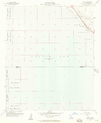
1956 Map of Salton
USGS Topo · Published 1957About this map
The Salton Sea dominates the northeastern corner of this 1956 survey, reaching an elevation of 235 feet below sea level. This specific shoreline, north of the Riverside and Imperial County line, reveals a landscape defined by the Southern Pacific railroad corridor and the establishing borders of Salton Sea State Park. The map documents a period of early desert development along the water, where Salton Beach and Betz Beach were accessible via primitive Jeep Trails. To the west, the expansive Torres Martinez Indian Reservation occupies the arid basin floor, largely undeveloped save for isolated markers like the Flight Course Pylon and a lonely Well. This document captures the intersection of industrial rail infrastructure, protected tribal lands, and the nascent recreational push into one of the lowest points in North America.
Find a feature on this map
11 named features on this map. Tap any name to fly to it.
Don’t see what you’re looking for? This feature index may not catch every label — zoom into the map to look around manually.
Map Details
Editions of this 1956 Salton Map
3 editions found
Other maps of this area

1904 · Indio
USGS Topo · 1:125,000

1931 · Vallecito
USGS Topo · 1:125,000

1940 · Cottonwood Spring
USGS Topo · 1:62,500

1940 · Durmid
USGS Topo · 1:62,500

1941 · Coachella
USGS Topo · 1:62,500

1942 · Agua Dulce
USGS Topo · 1:62,500

1943 · Vallecito
USGS Topo · 1:125,000

1943 · Coachella
USGS Topo · 1:62,500

1944 · Agua Dulce
USGS Topo · 1:62,500

1944 · Cottonwood Spring
USGS Topo · 1:62,500