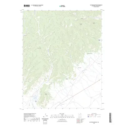
2023 Map of Saltpeter Mountain
USGS Topo · Published 2023About this map
Saltpeter Mountain rises above a deeply eroded landscape in this Colfax County survey, defined by a complex network of drainage systems including Saltpeter Canyon and Turkey Canyon. The area is characterized by seasonal watercourses like Saltpeter Creek and Curtis Creek, which flow through numerous named canyons such as Ashenfelder Canyon and Beardon Canyon. Transportation in this modern era is limited to specialized routes like Rail Canyon Rd and Co Rd A-45, alongside the primary corridor of US Route 64. Low-lying areas near the southern border feature the Twin Lakes, providing a rare aquatic contrast to the surrounding ridges. This map captures the topography of northern New Mexico, illustrating how the rugged terrain dictates the placement of rural roads and infrastructure in the high desert environment.
Find a feature on this map
15 named features on this map. Tap any name to fly to it.
Don’t see what you’re looking for? This feature index may not catch every label — zoom into the map to look around manually.
Map Details
Editions of this 2023 Saltpeter Mountain Map
This is the sole edition of this map. No revisions or reprints were ever made.
Other maps of this area

1915 · Brilliant
USGS Topo · 1:62,500

1915 · Koehler
USGS Topo · 1:62,500

1917 · Koehler
USGS Topo · 1:62,500

1954 · Raton
USGS Topo · 1:250,000

1955 · Cimarron
USGS Topo · 1:62,500

1958 · Raton
USGS Topo · 1:250,000

1962 · Casa Grande
USGS Topo · 1:62,500

1971 · Saltpeter Mountain
USGS Topo · 1:24,000
1971 · Curtis Camp
USGS Topo · 1:24,000
1971 · Red River Peak
USGS Topo · 1:24,000