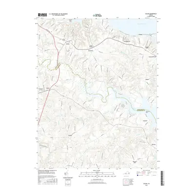
2016 Map of Saluda
USGS Topo · Published 2016About this map
Dragon Swamp and Courthouse Swamp dominate the low-lying interior of this Virginia landscape, where the Middlesex Co and Gloucester Co line divides the drainage basins of the Piankatank River and Poropotank River. The settlement of Saluda serves as a central hub, connected to outlying points like Cooks Corner and Stormont by a network of historic roads including Tidewater Trl and Raven Rd. To the north, the terrain reaches the banks of the Rappahannock River at Cooper, while the eastern portion of the sheet reveals a series of named points and small landings like Anderson Point and Sheppards Lndg. Evidence of long-standing community centers is found at Christchurch, which maintains its identity through the Christ Church Cem, and the Rappahannock Community Coll - Glenns Campus near the junction at Glenns. Further south, the map traces the intricate water systems of Callahan Swamp and Pratts Mill Swamp near the small crossroads of Harcum and Hornets Nest.
Find a feature on this map
122 named features on this map. Tap any name to fly to it.
Don’t see what you’re looking for? This feature index may not catch every label — zoom into the map to look around manually.
Map Details
Editions of this 2016 Saluda Map
This is the sole edition of this map. No revisions or reprints were ever made.
Other maps of this area

1906 · Williamsburg
USGS Topo · 1:62,500

1916 · Kilmarnock
USGS Topo · 1:48,000

1916 · Mathews
USGS Topo · 1:62,500

1917 · Urbanna
USGS Topo · 1:62,500

1917 · Kilmarnock
USGS Topo · 1:62,500

1917 · Mathews
USGS Topo · 1:62,500

1942 · Kilmarnock
USGS Topo · 1:62,500

1943 · Richmond
USGS Topo · 1:250,000
1946 · Urbanna
USGS Topo · 1:24,000

1948 · Ware Neck
USGS Topo · 1:24,000