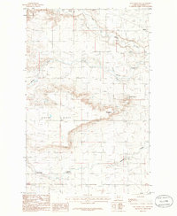
1985 Map of Sam George Hill
USGS Topo · Published 1986About this map
Benton Bench dominates the central topography of this Montana landscape, a broad plateau rising above the surrounding river valleys during the mid-1980s. The northern edge of the map is defined by the winding course of the Dry Fork Marias River, while the southern reaches are marked by the deep incision of Pondera Coulee. The small settlement of Manson sits near the northeastern corner, positioned near a series of gravel operations and the river fork. This provisional survey captures the region's agricultural and industrial character, noting an Oil Field in the southwest and several Radio Towers atop the high ground. The presence of a Spoil Bank and Conrad Reservoir indicates the modified hydrology of the area, where natural drainages like Creek and Spring are managed alongside human-made infrastructure on the high plains of Pondera County.
Find a feature on this map
18 named features on this map. Tap any name to fly to it.
Don’t see what you’re looking for? This feature index may not catch every label — zoom into the map to look around manually.
Map Details
Editions of this 1985 Sam George Hill Map
This is the sole edition of this map. No revisions or reprints were ever made.
Other maps of this area

1920 · Dupuyer
USGS Topo · 1:125,000

1920 · Conrad
USGS Topo · 1:125,000

1934 · Valier
USGS Topo · 1:62,500

1937 · Valier
USGS Topo · 1:62,500

1938 · Gallup City
USGS Topo · 1:62,500

1942 · Gallup City
USGS Topo · 1:62,500

1954 · Shelby
USGS Topo · 1:250,000

1958 · Shelby
USGS Topo · 1:250,000

1960 · Cut Bank
USGS Topo · 1:250,000

1963 · Cut Bank
USGS Topo · 1:250,000