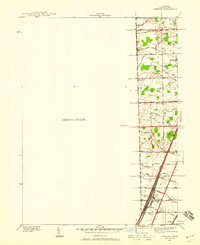
1939 Map of Samaria
USGS Topo · Published 1959About this map
Yargerville and the surrounding rural landscapes of Monroe County appear here just before the mid-century, defined by a complex network of agricultural drainage and early automotive corridors. The eastern edge of the quadrangle shows a transition from small settlements like Cousino and Kinney toward the industrial rail infrastructure at the southern end. The Pere Marquette railroad and the Dixie Hy run in close parallel, cutting a straight line through the drainage basins of Silver Creek and Little Lake Creek.
Find a feature on this map
51 named features on this map. Tap any name to fly to it.
Don’t see what you’re looking for? This feature index may not catch every label — zoom into the map to look around manually.
Map Details
Editions of this 1939 Samaria Map
This is the sole edition of this map. No revisions or reprints were ever made.
Other maps of this area

1900 · Maumee Bay
USGS Topo · 1:62,500

1900 · Toledo
USGS Topo · 1:62,500

1912 · Monroe
USGS Topo · 1:62,500

1912 · Dundee
USGS Topo · 1:62,500

1914 · Monroe
USGS Topo · 1:62,500

1926 · Dundee
USGS Topo · 1:62,500

1927 · Monroe
USGS Topo · 1:31,680

1934 · Point Place
USGS Topo · 1:24,000

1936 · Samaria
USGS Topo · 1:31,680
1936 · Erie
USGS Topo · 1:31,680
Featured Places
- Bedford Township, MI
- Temperance, Bedford Township
- LaSalle Township, MI
- Ida Township, MI
- Erie Township, MI