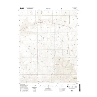
2016 Map of Sams
USGS Topo · Published 2016About this map
The high mesa and canyon country of San Miguel and Ouray counties come into focus through the small settlements of Sams and Noel. This terrain is defined by the sharp transition from the flat expanse of Hastings Mesa to the high summits of the Uncompahgre National Forest, including N Pole Peak and Hayden Peak. The complex drainage system of Leopard Cr and its various forks, such as Middle Fork Leopard Cr, illustrates the carved nature of the landscape near Price Canyon and Buck Canyon. A network of ranch roads and trails, such as Last Dollar Rd and the Whipple Mountain Trail, connect these high-altitude landholdings. Local aviation is represented by the Wilson Ranch Airport, situated on the plateau near Massy Gulch. This map provides a look at the contemporary land use of the region, where ranching heritage meets the protected wilderness near the Dallas Divide.
Find a feature on this map
63 named features on this map. Tap any name to fly to it.
Don’t see what you’re looking for? This feature index may not catch every label — zoom into the map to look around manually.
Map Details
Editions of this 2016 Sams Map
This is the sole edition of this map. No revisions or reprints were ever made.
Other maps of this area

1897 · Telluride
USGS Topo · 1:62,500

1904 · Telluride
USGS Topo · 1:62,500

1909 · Montrose
USGS Topo · 1:125,000

1911 · Montrose
USGS Topo · 1:125,000

1945 · Durango
USGS Topo · 1:250,000

1953 · Placerville
USGS Topo · 1:24,000
1953 · Gray Head
USGS Topo · 1:24,000

1953 · Little Cone
USGS Topo · 1:24,000

1953 · Durango
USGS Topo · 1:250,000

1954 · Durango
USGS Topo · 1:250,000