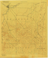
1954 Map of San Angelo
USGS Topo · Published 1967This historical map portrays the area of San Angelo in 1954, primarily covering Tom Green County as well as portions of Menard County, Irion County, Sterling County, Glasscock County, Midland County, Runnels County, Reagan County, Upton County, Coke County, Concho County, Crockett County, and Schleicher County. Featuring a scale of 1:250000, this map provides a highly detailed snapshot of the terrain, roads, buildings, counties, and historical landmarks in the San Angelo region at the time. Published in 1967, it is one of 2 known editions of this map due to revisions or reprints.
Find a feature on this map
85 named features on this map. Tap any name to fly to it.
Don’t see what you’re looking for? This feature index may not catch every label — zoom into the map to look around manually.
Map Details
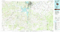
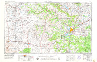
Editions of this 1954 San Angelo Map
2 editions found
Historical Maps of Stokes Through Time
5 maps found