1985 Map of San Antonio
USGS Topo · Published 1985About this map
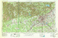
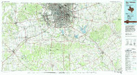
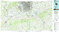
San Antonio dominates this mid-1980s landscape, surrounded by a dense ring of suburban communities and massive military installations that defined the region's growth. The city core is marked by landmarks such as the Tower of the Americas and Freeman Coliseum, while the National Cemetery and Fort Sam Houston Military Reservation reflect its deep ties to the nation's defense. The map captures the infrastructure of the era, including the Southern Pacific and Missouri Pacific railroad lines that intersect the urban center. Beyond the city, the land gives way to water features like Calaveras Lake and Braunig Lake, and smaller settlements like La Vernia and Floresville. The terrain is characterized by a series of low elevations such as Black Hill and Indian Hill, providing a backdrop to the network of creeks feeding the San Antonio River and Medina River.
Find a feature on this map
134 named features on this map. Tap any name to fly to it.
Don’t see what you’re looking for? This feature index may not catch every label — zoom into the map to look around manually.
Map Details
Editions of this 1985 San Antonio Map
3 editions found
Historical Maps of San Antonio Through Time
3 maps found