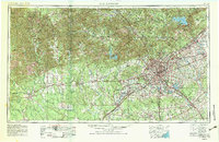
1954 Map of San Antonio
USGS Topo · Published 1983About this map
San Antonio and the surrounding Hill Country appear here during a period of significant mid-century growth and military expansion. The map clearly illustrates the transition from the rugged Edwards Plateau across the Balcones Escarpment into the coastal plains, showing how the city's urban footprint began to encircle established neighborhoods like Alamo Heights and Olmos Park. Extensive federal footprints including Lackland AFB, Kelly AFB, and the Camp Bullis Military Reservation anchor the regional economy, while the presence of the Southern Pacific and Missouri Pacific rail lines highlights the area's continued role as a transportation hub.
Find a feature on this map
139 named features on this map. Tap any name to fly to it.
Don’t see what you’re looking for? This feature index may not catch every label — zoom into the map to look around manually.
Map Details
Editions of this 1954 San Antonio Map
3 editions found

Other maps of this area

1887 · Blanco
USGS Topo · 1:125,000

1893 · Rock Springs
USGS Topo · 1:125,000

1893 · Nueces
USGS Topo · 1:125,000

1894 · Fredericksburg
USGS Topo · 1:125,000

1894 · Kerrville
USGS Topo · 1:125,000

1894 · Blanco
USGS Topo · 1:125,000

1896 · Nueces
USGS Topo · 1:125,000

1896 · Brackett
USGS Topo · 1:125,000

1896 · Austin
USGS Topo · 1:125,000

1897 · Brackett
USGS Topo · 1:125,000