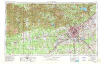
1954 Map of San Antonio
USGS Topo · Published 1980About this map
The city of San Antonio dominates the eastern half of this landscape, surrounded by an extensive network of military installations including Kelly AFB, Lackland AFB, and the Camp Bullis Military Reservation. The geography is defined by the Balcones Escarpment, which separates the coastal plains from the rising Edwards Plateau to the west. This transition is marked by numerous waterways like the Guadalupe River and Medina River, and the creation of large reservoirs such as Canyon Lake and Medina Lake. Toward the west, the terrain becomes more pronounced, featuring landmarks like Sulphur Mountain and the deep cuts of the Frio Canyon. Smaller settlements like Boerne, Bandera, and Uvalde serve as anchors for the ranching and hill country regions. The infrastructure of the era is clearly visible through the lines of the Southern Pacific and Missouri Pacific railroads, which connect the urban core to the surrounding counties.
Find a feature on this map
143 named features on this map. Tap any name to fly to it.
Don’t see what you’re looking for? This feature index may not catch every label — zoom into the map to look around manually.
Map Details
Editions of this 1954 San Antonio Map
3 editions found

Other maps of this area

1887 · Blanco
USGS Topo · 1:125,000

1893 · Rock Springs
USGS Topo · 1:125,000

1893 · Nueces
USGS Topo · 1:125,000

1894 · Fredericksburg
USGS Topo · 1:125,000

1894 · Kerrville
USGS Topo · 1:125,000

1894 · Blanco
USGS Topo · 1:125,000

1896 · Nueces
USGS Topo · 1:125,000

1896 · Brackett
USGS Topo · 1:125,000

1896 · Austin
USGS Topo · 1:125,000

1897 · Brackett
USGS Topo · 1:125,000