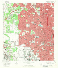
1967 Map of San Antonio West
USGS Topo · Published 1970About this map
Lackland Air Force Base and Kelly Air Force Base anchor the southwestern portion of this 1967 survey, illustrating the massive military presence that defined mid-century San Antonio. The landscape transitions from the dense urban grid of the city center to the sprawling institutional campuses of St Marys University and Our Lady of the Lake College. This era shows a community in heavy development, with the Wonderland Shopping Center and several drive-in theaters marking the shift toward car-centric suburban growth. Geologists and local historians can trace the course of Leon Creek as it winds past numerous Gravel Pits, a legacy of the area's industrial extraction. To the east, the historic foundations of the city are visible in the layout of the San Fernando Cem No 1 and the convergence of the Southern Pacific and Missouri Pacific railroads.
Find a feature on this map
104 named features on this map. Tap any name to fly to it.
Don’t see what you’re looking for? This feature index may not catch every label — zoom into the map to look around manually.
Map Details
Editions of this 1967 San Antonio West Map
Other maps of this area

1953 · Culebra Hill
USGS Topo · 1:24,000

1953 · San Antonio West
USGS Topo · 1:24,000

1953 · San Antonio East
USGS Topo · 1:24,000

1953 · Terrell Wells
USGS Topo · 1:24,000

1953 · Longhorn
USGS Topo · 1:24,000

1953 · Macdona
USGS Topo · 1:24,000

1953 · Southton
USGS Topo · 1:24,000

1953 · Helotes
USGS Topo · 1:24,000

1953 · Castle Hills
USGS Topo · 1:24,000

1954 · San Antonio
USGS Topo · 1:250,000