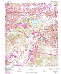
1966 Map of San Dimas
USGS Topo · Published 1984About this map
San Jose Hills and the Puente Hills dominate this mid-century landscape as the suburban expansion of Los Angeles County reaches eastward. The transition from agricultural valley to residential and institutional hubs is evident in the development of San Dimas, Glendora, and La Verne. Large-scale regional footprints, such as the California State Polytechnic University and the Naval Industrial Reserve Ordnance Plant, show the post-war shift toward educational and industrial infrastructure.
Find a feature on this map
58 named features on this map. Tap any name to fly to it.
Don’t see what you’re looking for? This feature index may not catch every label — zoom into the map to look around manually.
Map Details
Editions of this 1966 San Dimas Map
4 editions found
Other maps of this area

1894 · Pomona
USGS Topo · 1:62,500

1896 · Anaheim
USGS Topo · 1:62,500

1897 · Pomona
USGS Topo · 1:62,500

1897 · Cucamonga
USGS Topo · 1:62,500

1898 · Pomona
USGS Topo · 1:62,500

1898 · Anaheim
USGS Topo · 1:62,500

1900 · Cucamonga
USGS Topo · 1:62,500

1901 · Southern California Sheet No. 1
USGS Topo · 1:250,000

1901 · Anaheim
USGS Topo · 1:62,500

1902 · Corona
USGS Topo · 1:125,000