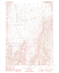
1990 Map of San Emidio Desert South
USGS Topo · Published 1990About this map
San Emidio Desert and the high ridges of the Lake Range define this high-desert region of Washoe County during the late 20th century. The southern portion of the sheet is dominated by the Pyramid Lake Indian Reservation, where the topography rises sharply toward peaks such as Wildcat Peak and Kits Peak. This map, updated from 1960s and 1980s aerial data, documents essential water sources in an arid landscape, including San Emidio Spring, Stag Spring, and the appropriately named Boiling Spring. Human presence is marked by isolated landmarks like the White Stage Flat Well on the edge of the White Sage Flat, while the natural drainage system is evidenced through several major corridors like San Emidio Canyon and Threemile Canyon. The map preserves the exact placement of early routes, including a simple Trail winding through Trail Canyon in the Fox Range.
Find a feature on this map
17 named features on this map. Tap any name to fly to it.
Don’t see what you’re looking for? This feature index may not catch every label — zoom into the map to look around manually.
Map Details
Editions of this 1990 San Emidio Desert South Map
This is the sole edition of this map. No revisions or reprints were ever made.
Other maps of this area

1886 · Granite Range
USGS Topo · 1:250,000

1894 · Granite Range
USGS Topo · 1:250,000

1955 · Lovelock
USGS Topo · 1:250,000

1959 · Lovelock
USGS Topo · 1:250,000
1964 · Tohakum Peak NE
USGS Topo · 1:24,000

1964 · Tohakum Peak NW
USGS Topo · 1:24,000

1964 · Kumiva Peak
USGS Topo · 1:62,500

1964 · Pyramid NE
USGS Topo · 1:24,000

1965 · Fox Range
USGS Topo · 1:62,500
1984 · Kumiva Peak
USGS Topo · 1:100,000