1964 Map of Tohakum Peak NE
USGS Topo · Published 1965About this map
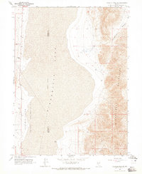
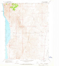
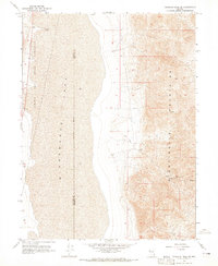
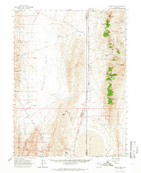
Winnemucca Lake dominates this mid-1960s landscape, occupying a broad basin on the border of Washoe and Pershing Counties. The eastern portion of the Pyramid Lake Indian Reservation extends into the dry lakebed, where an indefinite boundary marks the fluctuating shoreline. To the east, the Nightingale Mountains rise sharply, providing a dramatic contrast to the flat basin floor. Small-scale resource extraction is evident through scattered markers such as a Gravel Pit and isolated Prospect locations tucked into the foothills. Natural water sources like Goose Spring appear at the base of the mountains, while the rugged topography of Stonehouse Canyon and the prominent Needle Rock provide clear navigational landmarks for those traversing this desert environment. A simple network of Jeep Trails provides the primary access through the higher elevations.
Find a feature on this map
10 named features on this map. Tap any name to fly to it.
Don’t see what you’re looking for? This feature index may not catch every label — zoom into the map to look around manually.
Map Details
Editions of this 1964 Tohakum Peak NE Map
2 editions found

Other maps of this area

1886 · Granite Range
USGS Topo · 1:250,000

1894 · Granite Range
USGS Topo · 1:250,000

1955 · Lovelock
USGS Topo · 1:250,000

1959 · Lovelock
USGS Topo · 1:250,000
1964 · Dove Creek
USGS Topo · 1:24,000
1964 · Tohakum Peak SE
USGS Topo · 1:24,000
1964 · Tohakum Peak NW
USGS Topo · 1:24,000
1964 · Kumiva Peak
USGS Topo · 1:62,500
1981 · Tunnel Spring
USGS Topo · 1:24,000
1981 · Sage Hen Spring
USGS Topo · 1:24,000