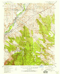
1954 Map of San Felipe Pueblo
USGS Topo · Published 1958About this map
Rio Grande waters sustain the ancient corridor through San Felipe Pueblo and Algodones in this mid-century topographic survey. The map records a landscape defined by complex Spanish land grants and indigenous sovereignty, including the San Felipe Pueblo Grant and Santo Domingo Pueblo Grant. Away from the river valley, the terrain transitions into the high country of the Cibola National Forest, where the legacy of early New Mexico industry is visible in Coal Mines (Aband) near Hagan and the Atchison Topeka and Santa Fe Railroad Grade. Cultural markers like the Mormon Battalion Monument and the prehistoric Tonque Pueblo (Ruins) alongside Arroyo Tonque provide a deep sense of the region's layered human history. Further east, the map identifies remote ranching outposts such as Diamond Tail Ranch and the site of Tejon, illustrating the pattern of settlement in the high desert before modern expansion.
Find a feature on this map
50 named features on this map. Tap any name to fly to it.
Don’t see what you’re looking for? This feature index may not catch every label — zoom into the map to look around manually.
Map Details
Editions of this 1954 San Felipe Pueblo Map
2 editions found

Other maps of this area

1888 · Bernalillo
USGS Topo · 1:125,000

1889 · Albuquerque
USGS Topo · 1:125,000

1890 · Jemes
USGS Topo · 1:125,000

1892 · San Pedro
USGS Topo · 1:125,000

1892 · Jemes
USGS Topo · 1:125,000

1892 · Santa Clara
USGS Topo · 1:125,000

1893 · Albuquerque
USGS Topo · 1:125,000

1934 · Alameda
USGS Topo · 1:24,000

1938 · Albuquerque
USGS Topo · 1:62,500

1943 · Jemez
USGS Topo · 1:62,500