
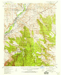
1954 Map of San Felipe Pueblo
USGS Topo · Published 1958About this map
San Felipe Pueblo occupies a central position along the Rio Grande in this mid-century survey, flanked by a network of intricate land grants and reservations. The landscape transitions from the river valley, where the Atchison Topeka and Santa Fe Railroad parallels the water, to the higher elevations of the Cibola National Forest. The eastern portion of the map provides a look at the former mining and ranching economy that once defined the area, with numerous abandoned operations such as Coal Mine (Aband) and Mina del Agua (Aband). Evidence of past settlement is preserved in the location of Tejon (Ghost Town) and Hagan (Ghost Town), reflecting the shifting population centers of Sandoval County. Historical landmarks like the Mormon Battalion Monument stand near the American Camino, marking the intersection of military history and early transit routes.
Find a feature on this map
54 named features on this map. Tap any name to fly to it.
Don’t see what you’re looking for? This feature index may not catch every label — zoom into the map to look around manually.
Map Details
Editions of this 1954 San Felipe Pueblo Map
2 editions found
Other maps of this area

1888 · Bernalillo
USGS Topo · 1:125,000

1889 · Albuquerque
USGS Topo · 1:125,000

1890 · Jemes
USGS Topo · 1:125,000

1892 · San Pedro
USGS Topo · 1:125,000

1892 · Jemes
USGS Topo · 1:125,000

1892 · Santa Clara
USGS Topo · 1:125,000

1893 · Albuquerque
USGS Topo · 1:125,000

1934 · Alameda
USGS Topo · 1:24,000

1938 · Albuquerque
USGS Topo · 1:62,500

1943 · Jemez
USGS Topo · 1:62,500