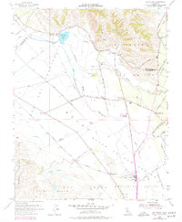
1955 Map of San Felipe
USGS Topo · Published 1977About this map
San Felipe Lake and the wetlands of the Tequisquita Slough dominate the low-lying basin where Santa Clara and San Benito counties meet. This mid-century landscape is defined by the transition from the high relief of the Ausaymas y San Felipe land grant down into the alluvial Hollister Valley. Small agricultural hubs like San Felipe and Dunneville anchor a network of rural roads, including Lovers Lane and Shore Road, which service the sprawling fields of the Llano de l Bolsa. The Southern Pacific railroad line cuts across the valley floor, connecting the pastoral outskirts of Hudner to larger markets. Infrastructure of the era is evident in the development of the Hollister Municipal Airport and numerous local schools such as Pacheco Sch and Fairhaven Sch, serving a dispersed farming community during a period of steady California expansion.
Find a feature on this map
40 named features on this map. Tap any name to fly to it.
Don’t see what you’re looking for? This feature index may not catch every label — zoom into the map to look around manually.
Map Details
Editions of this 1955 San Felipe Map
4 editions found
Other maps of this area

1915 · San Juan Bautista
USGS Topo · 1:48,000

1917 · Morgan Hill
USGS Topo · 1:62,500

1917 · San Juan Bautista
USGS Topo · 1:62,500

1919 · Hollister
USGS Topo · 1:48,000

1921 · Gilroy Hot Springs
USGS Topo · 1:62,500

1921 · Hollister
USGS Topo · 1:62,500

1923 · Hollister
USGS Topo · 1:62,500

1939 · Morgan Hill
USGS Topo · 1:62,500

1939 · Gilroy Hot Springs
USGS Topo · 1:62,500

1939 · San Juan Bautista
USGS Topo · 1:62,500