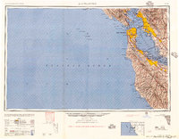
1957 Map of San Francisco
USGS Topo · Published 1957About this map
The Presidio of San Francisco and a series of coastal fortifications including Fort Funston and Fort Baker guard the entrance to the bay in this mid-century survey. The post-war expansion of the Bay Area is evident in the dense settlement patterns stretching from Richmond and Berkeley in the north down through the Peninsula to Palo Alto. Transport infrastructure is the defining characteristic of the landscape, with major spans like the Golden Gate Bridge and the San Francisco-Oakland Bay Bridge linking the region's urban centers. Beyond the metropolitan core, the map detail follows the Southern Pacific rail lines and the winding course of the San Lorenzo River toward the south. Military installations such as Moffett Field and Fort Mason reflect the strategic importance of the harbor during this era of maritime and aerial development.
Find a feature on this map
185 named features on this map. Tap any name to fly to it.
Don’t see what you’re looking for? This feature index may not catch every label — zoom into the map to look around manually.
Map Details
Editions of this 1957 San Francisco Map
This is the sole edition of this map. No revisions or reprints were ever made.
Other maps of this area

1889 · San Jose
USGS Topo · 1:62,500

1892 · San Mateo
USGS Topo · 1:62,500

1895 · San Francisco
USGS Topo · 1:62,500

1896 · San Mateo
USGS Topo · 1:62,500

1896 · Carquinez Strait
USGS Topo · 1:62,500

1896 · Mt. Diablo
USGS Topo · 1:62,500

1897 · San Jose
USGS Topo · 1:62,500

1897 · Concord
USGS Topo · 1:62,500

1897 · Palo Alto
USGS Topo · 1:62,500

1897 · Tamalpais
USGS Topo · 1:62,500