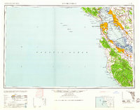
1960 Map of San Francisco
USGS Topo · Published 1960About this map
San Francisco Bay serves as the central focal point of this mid-century landscape, illustrating the post-war urbanization and infrastructure of the region. The map documents the critical transit links between the peninsula and the East Bay, including the San Francisco-Oakland Bay Bridge and the San Mateo-Hayward Toll Bridge. Military installations remain prominent features of the coastal defense system, with extensive holdings at the Presidio of San Francisco and various island outposts like Fort McDowell on Angel Island.
Find a feature on this map
157 named features on this map. Tap any name to fly to it.
Don’t see what you’re looking for? This feature index may not catch every label — zoom into the map to look around manually.
Map Details
Editions of this 1960 San Francisco Map
This is the sole edition of this map. No revisions or reprints were ever made.
Other maps of this area

1889 · San Jose
USGS Topo · 1:62,500

1892 · San Mateo
USGS Topo · 1:62,500

1895 · San Francisco
USGS Topo · 1:62,500

1896 · San Mateo
USGS Topo · 1:62,500

1896 · Carquinez Strait
USGS Topo · 1:62,500

1896 · Mt. Diablo
USGS Topo · 1:62,500

1897 · San Jose
USGS Topo · 1:62,500

1897 · Concord
USGS Topo · 1:62,500

1897 · Palo Alto
USGS Topo · 1:62,500

1897 · Tamalpais
USGS Topo · 1:62,500