1949 Map of San German SO
USGS Topo · Published 1949About this map
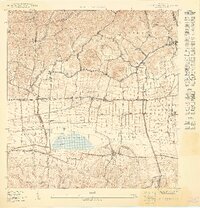
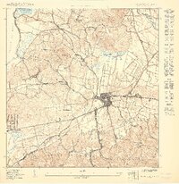
Laguna Cartagena dominates the central lowlands of this 1949 survey, situated within the fertile Valle de Lajas. The landscape is a study in transition between the steep northern hills and the expansive agricultural flats. The American Railroad of Porto Rico cuts across the valley floor, providing a vital transportation artery for the historic agricultural estates of the region, including Hacienda Desengaño, Hacienda Resolución, and Hacienda Luisa. These estates and the surrounding small settlements like Guanábana and El Brujo suggest an economy deeply tied to the land and the rail network.
Find a feature on this map
35 named features on this map. Tap any name to fly to it.
Don’t see what you’re looking for? This feature index may not catch every label — zoom into the map to look around manually.
Map Details
Editions of this 1949 San German SO Map
This is the sole edition of this map. No revisions or reprints were ever made.
Other maps of this area

1935 · Puerto Real
USGS Topo · 1:25,000

1937 · San German
USGS Topo · 1:25,000

1937 · Puerto Real
USGS Topo · 1:25,000

1938 · Parguera
USGS Topo · 1:30,000
1938 · Cabo Rojo
USGS Topo · 1:30,000

1941 · San German
USGS Topo · 1:30,000

1941 · Puerto Real
USGS Topo · 1:30,000
1949 · Puerto Real SE
USGS Topo · 1:10,000
1949 · Cabo Rojo NE
USGS Topo · 1:10,000
1949 · Puerto Real NE
USGS Topo · 1:10,000