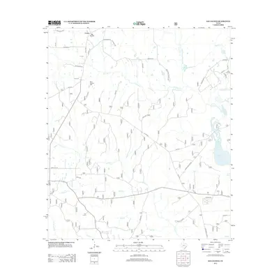
2013 Map of San Jacinto
USGS Topo · Published 2013About this map
Goshen and the namesake settlement of San Jacinto sit in the northern reaches of this Walker County landscape, an area characterized by a dense network of creek drainages and forest roads. The terrain is dominated by the W Fork San Jacinto River and its many tributaries, including W Sandy Cr, Caney Cr, and Kelly Br, which carve through the land near prominent elevations like Blue Bonnet Hill.
Find a feature on this map
44 named features on this map. Tap any name to fly to it.
Don’t see what you’re looking for? This feature index may not catch every label — zoom into the map to look around manually.
Map Details
Editions of this 2013 San Jacinto Map
This is the sole edition of this map. No revisions or reprints were ever made.
Other maps of this area

1954 · Beaumont
USGS Topo · 1:250,000

1957 · Beaumont
USGS Topo · 1:250,000

1958 · Lake Paula
USGS Topo · 1:24,000

1959 · Moore Grove
USGS Topo · 1:24,000

1959 · San Jacinto
USGS Topo · 1:24,000

1959 · Montgomery
USGS Topo · 1:24,000

1962 · Dacus
USGS Topo · 1:24,000

1962 · Richards
USGS Topo · 1:24,000

1962 · Galilee
USGS Topo · 1:24,000
1963 · Loma
USGS Topo · 1:24,000