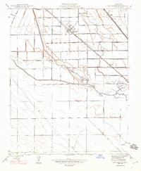
1947 Map of San Joaquin
USGS Topo · Published 1947About this map
The agricultural grid of Fresno County is defined here by the intersection of irrigation engineering and rail transport in the mid-1940s. The town of San Joaquin serves as the central hub, situated along the Southern Pacific railroad line and surrounded by a dense network of named roads like Manning Ave and Mountain View Ave. This revision captures the landscape as it functioned after the initial 1923 mapping, highlighting the critical role of water management in the Central Valley.
Find a feature on this map
34 named features on this map. Tap any name to fly to it.
Don’t see what you’re looking for? This feature index may not catch every label — zoom into the map to look around manually.
Map Details
Editions of this 1947 San Joaquin Map
This is the sole edition of this map. No revisions or reprints were ever made.
Other maps of this area

1912 · Coalinga
USGS Topo · 1:125,000

1923 · Englebrecht Ranch
USGS Topo · 1:31,680

1924 · Jamesan
USGS Topo · 1:31,680

1924 · Tranquillity
USGS Topo · 1:31,680

1925 · Helm
USGS Topo · 1:31,680

1925 · San Joaquin
USGS Topo · 1:31,680

1931 · Wheatville
USGS Topo · 1:31,680

1931 · Towne Oil Station
USGS Topo · 1:31,680

1931 · Mouth of Cantua Creek
USGS Topo · 1:31,680

1943 · Joaquin Rocks
USGS Topo · 1:62,500