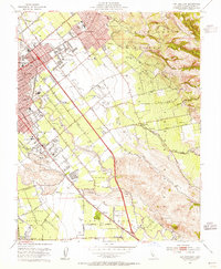
1953 Map of San Jose East
USGS Topo · Published 1955About this map
The expanding urban edge of San Jose meets the agricultural valleys and foothills of the Santa Teresa Hills in this mid-century survey. The landscape is a mix of established community institutions and the emerging infrastructure of a growing city, featuring the County Fairground, the San Jose Speedway, and aviation activity at Reids Hillview Airport. Education is a clear priority in the developing neighborhoods, with numerous schools such as James Lick High Sch and Franklin McKinley Sch appearing as anchors for local families.
Find a feature on this map
42 named features on this map. Tap any name to fly to it.
Don’t see what you’re looking for? This feature index may not catch every label — zoom into the map to look around manually.
Map Details
Editions of this 1953 San Jose East Map
This is the sole edition of this map. No revisions or reprints were ever made.
Other maps of this area

1889 · San Jose
USGS Topo · 1:62,500

1897 · San Jose
USGS Topo · 1:62,500

1897 · Mt. Hamilton
USGS Topo · 1:62,500

1899 · San Jose
USGS Topo · 1:62,500

1916 · New Almaden
USGS Topo · 1:48,000

1917 · Morgan Hill
USGS Topo · 1:62,500

1919 · New Almaden
USGS Topo · 1:62,500

1939 · Morgan Hill
USGS Topo · 1:62,500

1940 · Los Gatos
USGS Topo · 1:62,500

1941 · Morgan Hill
USGS Topo · 1:62,500