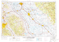
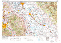
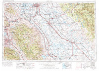
1962 Map of San Jose
USGS Topo · Published 1977About this map
The Santa Clara Valley and San Joaquin Valley meet in this expansive mid-century survey, documenting a period of significant infrastructural development across Central California. The landscape is defined by the massive water management systems of the era, including the San Luis Reservoir, Hetch Hetchy Reservoir, and the Don Pedro Reservoir, which anchor the foothills of the Diablo Range. This geography is further characterized by the heavy presence of the United States military at Sharpe General Depot and Castle Air Force Base, reflecting the strategic importance of the region during the Cold War.
Find a feature on this map
277 named features on this map. Tap any name to fly to it.
Don’t see what you’re looking for? This feature index may not catch every label — zoom into the map to look around manually.
Map Details
Editions of this 1962 San Jose Map
4 editions found

Other maps of this area

1889 · Jackson
USGS Topo · 1:125,000

1889 · San Jose
USGS Topo · 1:62,500

1891 · Big Trees
USGS Topo · 1:125,000

1892 · Jackson
USGS Topo · 1:125,000

1893 · Sonora
USGS Topo · 1:125,000

1894 · Big Trees
USGS Topo · 1:125,000

1894 · Lodi
USGS Topo · 1:125,000

1896 · Dardanelles
USGS Topo · 1:125,000

1896 · Sonora
USGS Topo · 1:125,000

1896 · Carquinez Strait
USGS Topo · 1:62,500