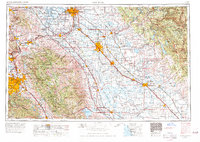
1962 Map of San Jose
USGS Topo · Published 1971About this map
The Diablo Range and Santa Cruz Mountains form the topographical backbone of this mid-century survey, which reveals the transition of the Santa Clara Valley and Central Valley before the peak of suburban expansion. From the urban core of San Jose to the agricultural hubs of Modesto and Stockton, the map documents an era of significant infrastructure, including the Delta-Mendota Canal, the California Aqueduct, and the Hetch Hetchy Aqueduct. Regional transport relies heavily on a dense network of lines like the Southern Pacific RR and the Western Pacific RR, which serve smaller communities such as Tracy, Livermore, and Gilroy. This 1:250,000 scale map effectively illustrates the complex water management systems and river networks, including the San Joaquin River and Stanislaus River, that sustained the region's diverse economy during the 1960s.
Find a feature on this map
272 named features on this map. Tap any name to fly to it.
Don’t see what you’re looking for? This feature index may not catch every label — zoom into the map to look around manually.
Map Details
Editions of this 1962 San Jose Map
4 editions found

Other maps of this area

1889 · Jackson
USGS Topo · 1:125,000

1889 · San Jose
USGS Topo · 1:62,500

1891 · Big Trees
USGS Topo · 1:125,000

1892 · Jackson
USGS Topo · 1:125,000

1893 · Sonora
USGS Topo · 1:125,000

1894 · Big Trees
USGS Topo · 1:125,000

1894 · Lodi
USGS Topo · 1:125,000

1896 · Dardanelles
USGS Topo · 1:125,000

1896 · Sonora
USGS Topo · 1:125,000

1896 · Carquinez Strait
USGS Topo · 1:62,500