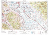
1962 Map of San Jose
USGS Topo · Published 1977About this map
San Jose and the Santa Clara Valley serve as the western anchors for this regional study, which extends across the San Joaquin Valley to the gates of the Sierra Nevada. The landscape is defined by massive water management infrastructure, including the Mokelumne Aqueduct, California Aqueduct, and the Delta-Mendota Canal, illustrating the 1960s-era transformation of California's agricultural and urban corridors. This edition shows the density of the state's post-war transit network, anchored by the Southern Pacific and Western Pacific railroads alongside U S Highway 99. From the Lick Observatory atop Mount Hamilton to the eastern expanse of Yosemite National Park, the map documents a mix of military sites like Sharpe General Depot, industrial landmarks like the Sugar refinery near Tracy, and established educational centers including Stanford University.
Find a feature on this map
313 named features on this map. Tap any name to fly to it.
Don’t see what you’re looking for? This feature index may not catch every label — zoom into the map to look around manually.
Map Details
Editions of this 1962 San Jose Map
4 editions found

Other maps of this area

1889 · Jackson
USGS Topo · 1:125,000

1889 · San Jose
USGS Topo · 1:62,500

1891 · Big Trees
USGS Topo · 1:125,000

1892 · Jackson
USGS Topo · 1:125,000

1893 · Sonora
USGS Topo · 1:125,000

1894 · Big Trees
USGS Topo · 1:125,000

1894 · Lodi
USGS Topo · 1:125,000

1896 · Dardanelles
USGS Topo · 1:125,000

1896 · Sonora
USGS Topo · 1:125,000

1896 · Carquinez Strait
USGS Topo · 1:62,500