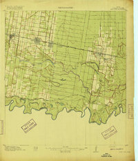
1916 Map of San Juan
USGS Topo · Published 1949About this map
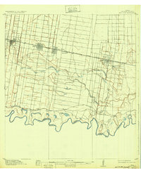
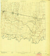
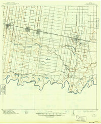
Irrigation canals and fledgling rail towns define this South Texas landscape along the United States Mexico Boundary Line. In the years before the First World War, the Louisiana Rio Grande Canal and the Edinburg Branch represent a massive engineering effort to transform the arid brushland into productive citrus and vegetable acreage. The settlement pattern follows the St Louis Brownsville and Mexico railroad line, where towns like Mc Allen, Pharr, and San Juan are emerging as agricultural shipping hubs. To the south, the meandering Rio Grande creates a complex network of oxbow lakes and dry channels, such as Sardinas Resaca and La Cruz Resaca, which dictated early land divisions like the Valley View Plantation. Traces of older transit routes remain visible via the Military Road, which parallels the river's winding course through the borderlands.
Find a feature on this map
27 named features on this map. Tap any name to fly to it.
Don’t see what you’re looking for? This feature index may not catch every label — zoom into the map to look around manually.
Map Details
Editions of this 1916 San Juan Map
3 editions found