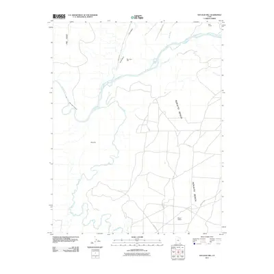
2011 Map of San Juan Hill
USGS Topo · Published 2011About this map
San Juan Hill rises above a dramatic landscape shaped by the San Juan River and its intricate drainage network in southeastern Utah. This modern topographic record details the winding path of Chinle Creek as it meanders toward the river, cutting through the distinctive geological formations of Nokaito Bench and Lime Ridge. The map reveals the relationship between traditional natural crossings and modern access, with Comb Wash and Butler Wash providing structural orientation for backcountry travel. Notable landmarks such as the Mule Ear outcrop and the secluded Bogus Pocket provide specific points of interest for those studying the physical geography of the Shiprock Agency region. Infrastructure is represented by the Bluff Airport in the northeast and a network of county roads including Comb Ridge Rd and Chinle Creek Rd, which connect these remote desert features.
Find a feature on this map
22 named features on this map. Tap any name to fly to it.
Don’t see what you’re looking for? This feature index may not catch every label — zoom into the map to look around manually.
Map Details
Editions of this 2011 San Juan Hill Map
This is the sole edition of this map. No revisions or reprints were ever made.
Other maps of this area

1886 · Abajo
USGS Topo · 1:250,000

1892 · Abajo
USGS Topo · 1:250,000

1893 · Abajo
USGS Topo · 1:250,000

1952 · Bluff 3 SE
USGS Topo · 1:24,000

1956 · Cortez
USGS Topo · 1:250,000

1958 · Cortez
USGS Topo · 1:250,000

1959 · Cortez
USGS Topo · 1:250,000

1962 · Cortez
USGS Topo · 1:250,000

1962 · Bluff
USGS Topo · 1:62,500
1962 · Bluff SW
USGS Topo · 1:24,000