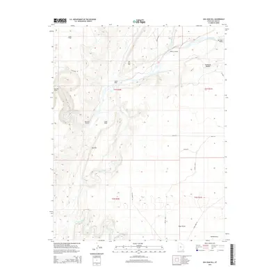
2014 Map of San Juan Hill
USGS Topo · Published 2014About this map
San Juan River meanders through this high desert landscape, carving the dramatic San Juan Canyon as it flows westward. The topography is defined by the sharp verticality of Comb Ridge, a prominent monocline that dictates the drainage patterns of both Comb Wash and Butler Wash. The small settlement of Tselakai Dezza sits on the eastern edge of the survey, connected by Bia-5058. This 2014 survey documents a network of remote corridors including Lime Ridge Rd and Chinle Creek Rd, which provide access to notable landmarks such as Mule Ear and the broad Nokaito Bench. The confluence of Chinle Creek and the river marks a transition in the terrain, reflecting the arid character of the San Juan Valley and the surrounding mesas.
Find a feature on this map
25 named features on this map. Tap any name to fly to it.
Don’t see what you’re looking for? This feature index may not catch every label — zoom into the map to look around manually.
Map Details
Editions of this 2014 San Juan Hill Map
This is the sole edition of this map. No revisions or reprints were ever made.
Other maps of this area

1886 · Abajo
USGS Topo · 1:250,000

1892 · Abajo
USGS Topo · 1:250,000

1893 · Abajo
USGS Topo · 1:250,000

1952 · Bluff 3 SE
USGS Topo · 1:24,000

1956 · Cortez
USGS Topo · 1:250,000

1958 · Cortez
USGS Topo · 1:250,000

1959 · Cortez
USGS Topo · 1:250,000

1962 · Cortez
USGS Topo · 1:250,000

1962 · Bluff
USGS Topo · 1:62,500
1962 · Bluff SW
USGS Topo · 1:24,000