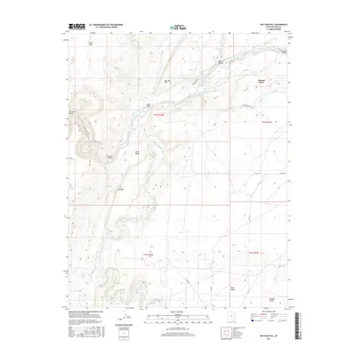
2017 Map of San Juan Hill
USGS Topo · Published 2017About this map
San Juan Hill and the towering Comb Ridge anchor this desert landscape, where the San Juan River carves deep through San Juan Canyon and the San Juan Valley. The terrain is defined by dramatic geological breaks and drainage systems, with the waters of Chinle Creek, Butler Wash, and Comb Wash all converging toward the river's path. In the eastern portion of the quadrangle, the settlement of Tselakai Dezza sits near the headwaters of Gothic Cr, while isolated landmarks like Mule Ear and Lime Ridge serve as prominent points of orientation across the high plateau.
Find a feature on this map
30 named features on this map. Tap any name to fly to it.
Don’t see what you’re looking for? This feature index may not catch every label — zoom into the map to look around manually.
Map Details
Editions of this 2017 San Juan Hill Map
This is the sole edition of this map. No revisions or reprints were ever made.
Other maps of this area

1886 · Abajo
USGS Topo · 1:250,000

1892 · Abajo
USGS Topo · 1:250,000

1893 · Abajo
USGS Topo · 1:250,000

1952 · Bluff 3 SE
USGS Topo · 1:24,000

1956 · Cortez
USGS Topo · 1:250,000

1958 · Cortez
USGS Topo · 1:250,000

1959 · Cortez
USGS Topo · 1:250,000

1962 · Cortez
USGS Topo · 1:250,000

1962 · Bluff
USGS Topo · 1:62,500
1962 · Bluff SW
USGS Topo · 1:24,000