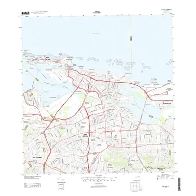
2013 Map of San Juan
USGS Topo · Published 2013About this map
Punta del Morro and the historic Isleta de San Juan anchor this detailed 2013 survey of the Puerto Rican capital, showing the dense urban transition from old fortifications to modern metropolitan infrastructure. The map documents the city's complex hydrology, from the Bahía de San Juan to the winding Caño de Martin Peña and numerous creeks like Quebrada Margarita. Transportation networks are a primary focus, including the Teodoro Moscoso Bridge and the Estacion Sagrado Corazón rail terminal.
Find a feature on this map
82 named features on this map. Tap any name to fly to it.
Don’t see what you’re looking for? This feature index may not catch every label — zoom into the map to look around manually.
Map Details
Editions of this 2013 San Juan Map
This is the sole edition of this map. No revisions or reprints were ever made.
Other maps of this area

1940 · Carolina
USGS Topo · 1:30,000

1941 · Bayamon
USGS Topo · 1:30,000

1941 · San Juan
USGS Topo · 1:30,000

1941 · Carolina
USGS Topo · 1:30,000

1946 · Aguas Buenas
USGS Topo · 1:30,000

1946 · Naranjito
USGS Topo · 1:30,000

1946 · Gurabo
USGS Topo · 1:30,000

1947 · Carolina
USGS Topo · 1:30,000

1947 · Aguas Buenas NO
USGS Topo · 1:10,000

1947 · Bayamon
USGS Topo · 1:30,000