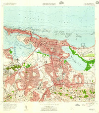
1957 Map of San Juan
USGS Topo · Published 1959About this map
San Juan's coastal and urban development is remarkably detailed in this late-1950s record, showcasing the dense expansion of barrios like Santurce and Condado alongside the defensive history of Fort Brooke. The map documents a critical period of infrastructure growth, featuring the newly built Aeropuerto Internacional de Isla Verde and the essential waterways of the Cano de Martín Peña and Laguna San José. In the Rio Piedras district, the Universidad de Puerto Rico stands as a focal point of the southern metropolitan area. From the historic La Fortaleza at the mouth of the Bahía de San Juan to the industrial rail lines of the Ferrocarriles de Puerto Rico, the sheet captures the shift from a colonial fortress city to a modern Caribbean capital. Local life is represented through numerous neighborhood parks like Parque Sixto Escobar and public facilities including the Hospital Municipal.
Find a feature on this map
160 named features on this map. Tap any name to fly to it.
Don’t see what you’re looking for? This feature index may not catch every label — zoom into the map to look around manually.
Map Details
Editions of this 1957 San Juan Map
This is the sole edition of this map. No revisions or reprints were ever made.
Other maps of this area

1940 · Carolina
USGS Topo · 1:30,000

1941 · Bayamon
USGS Topo · 1:30,000

1941 · San Juan
USGS Topo · 1:30,000

1941 · Carolina
USGS Topo · 1:30,000

1946 · Aguas Buenas
USGS Topo · 1:30,000

1946 · Naranjito
USGS Topo · 1:30,000

1946 · Gurabo
USGS Topo · 1:30,000

1947 · Carolina
USGS Topo · 1:30,000

1947 · Aguas Buenas NO
USGS Topo · 1:10,000

1947 · Bayamon
USGS Topo · 1:30,000