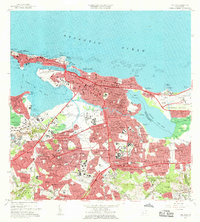
1963 Map of San Juan
USGS Topo · Published 1965About this map
San Juan presents as a complex urban and coastal environment during a period of significant mid-century expansion. The historic core, including La Fortaleza and Fuerte San Cristobal, stands at the western tip, while the growth of neighborhoods like Santurce, Miramar, and Villa Palmeras reflects the densification of the metropolitan area. The landscape is defined by its intricate waterways, from the Bahía de San Juan and Caño de San Antonio to the inland Laguna San José.
Find a feature on this map
213 named features on this map. Tap any name to fly to it.
Don’t see what you’re looking for? This feature index may not catch every label — zoom into the map to look around manually.
Map Details
Editions of this 1963 San Juan Map
This is the sole edition of this map. No revisions or reprints were ever made.
Other maps of this area

1940 · Carolina
USGS Topo · 1:30,000

1941 · Bayamon
USGS Topo · 1:30,000

1941 · San Juan
USGS Topo · 1:30,000

1941 · Carolina
USGS Topo · 1:30,000

1946 · Aguas Buenas
USGS Topo · 1:30,000

1946 · Naranjito
USGS Topo · 1:30,000

1946 · Gurabo
USGS Topo · 1:30,000

1947 · Carolina
USGS Topo · 1:30,000

1947 · Aguas Buenas NO
USGS Topo · 1:10,000

1947 · Bayamon
USGS Topo · 1:30,000