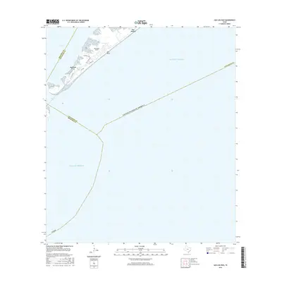
2016 Map of San Luis Pass
USGS Topo · Published 2016About this map
Galveston Island terminates at its southwestern tip here, where the waters of West Bay meet the open Gulf of Mexico through the narrow San Luis Pass. This coastal boundary area between Galveston and Brazoria counties captures the modern residential layout of communities like Bay Harbor and the development at West Beach. The transition from the sheltered waters of Red Fish Cove to the beach-facing properties along San Luis Pass Rd and Bay Breeze Dr reflects the ongoing evolution of this barrier island landscape. The map emphasizes the maritime and tidal nature of the region, detailing the shifting inlets and coastal roads that define the area's geography as it appeared in the mid-2010s.
Find a feature on this map
18 named features on this map. Tap any name to fly to it.
Don’t see what you’re looking for? This feature index may not catch every label — zoom into the map to look around manually.
Map Details
Editions of this 2016 San Luis Pass Map
This is the sole edition of this map. No revisions or reprints were ever made.
Other maps of this area

1929 · Karankawa Lake
USGS Topo · 1:24,000

1931 · Lake Como
USGS Topo · 1:24,000

1933 · Karankawa Lake
USGS Topo · 1:31,680

1933 · San Luis Pass
USGS Topo · 1:31,680
1933 · Lake Como
USGS Topo · 1:31,680

1943 · San Luis Pass
USGS Topo · 1:31,680
1943 · Lake Como
USGS Topo · 1:25,000
1943 · Carancahua Lake
USGS Topo · 1:24,000

1943 · Christmas Point
USGS Topo · 1:24,000

1943 · Chocolate Bay
USGS Topo · 1:24,000