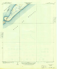
1933 Map of San Luis Pass
USGS Topo · Published 1949About this map
Galveston Island and its southwestern tip are the primary focus of this maritime survey, illustrating the dynamic coastal landscape of the Texas Gulf Coast as it appeared in the early 1930s. The map captures the narrow, undeveloped spit of land guarded by the San Luis Coast Guard station, a vital landmark for navigation and safety along this exposed stretch of shoreline. The boundary between Brazoria Co and Galveston Co bisects the treacherous waters of San Luis Pass, a natural break separating the main island from San Luis Island. This era of the coast is documented prior to significant modern development, showing the shifting sands and salt marshes that define the interface between West Bay and the open Gulf of Mexico. The survey provides a clear view of the natural hydrology and coastal defenses of the region during the interwar period.
Find a feature on this map
7 named features on this map. Tap any name to fly to it.
Don’t see what you’re looking for? This feature index may not catch every label — zoom into the map to look around manually.
Map Details
Editions of this 1933 San Luis Pass Map
2 editions found
Other maps of this area

1929 · Karankawa Lake
USGS Topo · 1:24,000

1931 · Lake Como
USGS Topo · 1:24,000

1933 · Karankawa Lake
USGS Topo · 1:31,680

1933 · San Luis Pass
USGS Topo · 1:31,680
1933 · Lake Como
USGS Topo · 1:31,680

1943 · San Luis Pass
USGS Topo · 1:31,680
1943 · Lake Como
USGS Topo · 1:25,000
1943 · Carancahua Lake
USGS Topo · 1:24,000

1943 · Christmas Point
USGS Topo · 1:24,000

1943 · Chocolate Bay
USGS Topo · 1:24,000