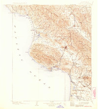
1900 Map of San Luis
USGS Topo · Published 1930About this map
The coastal landscapes of San Luis Obispo and the surrounding ranchos are captured here as they appeared at the end of the 19th century. The Southern Pacific RR serves as the primary artery for the region, winding through the hills from Santa Margarita down to the sea. The maritime economy is centered on San Luis Obispo Bay, where Port Harford and Mallagh Landing provide critical shipping points for the inland agricultural and mineral outputs.
Find a feature on this map
90 named features on this map. Tap any name to fly to it.
Don’t see what you’re looking for? This feature index may not catch every label — zoom into the map to look around manually.
Map Details
Editions of this 1900 San Luis Map
4 editions found
Other maps of this area

1897 · Port Harford
USGS Topo · 1:62,500

1897 · San Luis Obispo
USGS Topo · 1:62,500

1897 · Cayucos
USGS Topo · 1:62,500

1897 · Arroyo Grande
USGS Topo · 1:62,500

1900 · San Luis
USGS Topo · 1:125,000

1905 · Guadalupe
USGS Topo · 1:125,000

1905 · Lompoc
USGS Topo · 1:125,000

1914 · Cholame
USGS Topo · 1:125,000

1915 · Cholame
USGS Topo · 1:125,000

1917 · Cholame
USGS Topo · 1:125,000