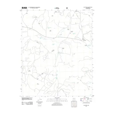
2011 Map of San Mateo
USGS Topo · Published 2011About this map
The Kin Nizhoni Archaeological District sits north of the village of San Mateo, anchoring a landscape defined by its deep mining history and seasonal water management. This high-altitude desert region is marked by extensive mineral extraction, including the San Mateo Mine, Johnny M Mine, and various Uranium Prospects. Ranching interests are represented by the Marcus Ranch and Lee Ranch, where life revolves around vital water sources like Bridge Spring and San Mateo Reservoir. The road network, including the San Mateo Main St and Jesus Mesa Rd, connects these remote industrial and agricultural sites across the mesas and canyons. From the Palo Verde Group mines in the north to the Bajios Largo in the south, the map illustrates the 21st-century footprint of energy production and cattle raising in Cibola County.
Find a feature on this map
57 named features on this map. Tap any name to fly to it.
Don’t see what you’re looking for? This feature index may not catch every label — zoom into the map to look around manually.
Map Details
Editions of this 2011 San Mateo Map
This is the sole edition of this map. No revisions or reprints were ever made.
Other maps of this area

1883 · Mt. Taylor
USGS Topo · 1:250,000

1886 · Mt. Taylor
USGS Topo · 1:250,000

1892 · Mt. Taylor
USGS Topo · 1:250,000

1899 · Mt. Taylor
USGS Topo · 1:250,000

1957 · Lobo Springs
USGS Topo · 1:24,000

1957 · Ambrosia Lake
USGS Topo · 1:24,000

1957 · Mount Taylor
USGS Topo · 1:24,000

1957 · Dos Lomas
USGS Topo · 1:24,000
1957 · Grants
USGS Topo · 1:24,000

1958 · Albuquerque
USGS Topo · 1:250,000