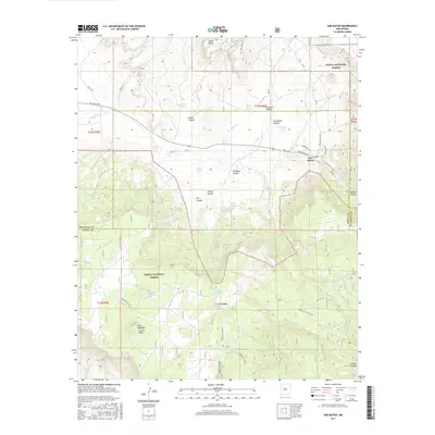
2017 Map of San Mateo
USGS Topo · Published 2017About this map
The settlement of San Mateo serves as the focal point of this Northern New Mexico landscape, situated at the base of the mountain ranges within the Cibola National Forest. The map illustrates a high-desert environment defined by dramatic elevation changes, moving from the valley floor to the prominent heights of Jesus Mesa and La Jara Mesa. A complex network of canyons, including Rafael Canyon and Marquez Canyon, dissects the terrain, while life in this arid region is centered around critical water sources like San Mateo Creek, San Mateo Reservoir, and numerous named catchments such as Bull Pasture Tank and Lee Stock Tank.
Find a feature on this map
56 named features on this map. Tap any name to fly to it.
Don’t see what you’re looking for? This feature index may not catch every label — zoom into the map to look around manually.
Map Details
Editions of this 2017 San Mateo Map
This is the sole edition of this map. No revisions or reprints were ever made.
Other maps of this area

1883 · Mt. Taylor
USGS Topo · 1:250,000

1886 · Mt. Taylor
USGS Topo · 1:250,000

1892 · Mt. Taylor
USGS Topo · 1:250,000

1899 · Mt. Taylor
USGS Topo · 1:250,000

1957 · Lobo Springs
USGS Topo · 1:24,000

1957 · Ambrosia Lake
USGS Topo · 1:24,000

1957 · Mount Taylor
USGS Topo · 1:24,000

1957 · Dos Lomas
USGS Topo · 1:24,000
1957 · Grants
USGS Topo · 1:24,000

1958 · Albuquerque
USGS Topo · 1:250,000