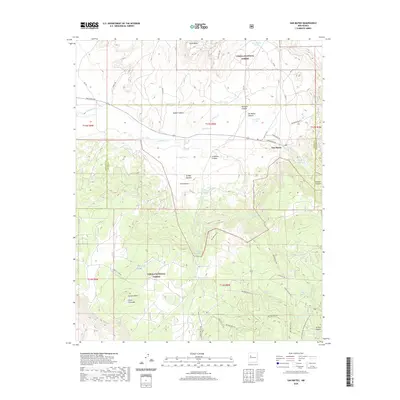
2020 Map of San Mateo
USGS Topo · Published 2020About this map
The settlement of San Mateo sits at the foot of the high country, serving as a hub for the surrounding ranching and forest lands. The landscape is defined by its water management, with numerous named tanks such as Bull Pasture Tank and Youngs Tank sustaining livestock across the varying elevations. To the south, the terrain rises sharply toward La Jara Mesa and the prominent Cerro Colorado, where the Cibola National Forest encompasses deep drainages like El Rito Canyon and Rafael Canyon. This 2020 survey reveals a complex network of forest and county roads that provide access to remote springs, including Lobo Springs and Rock Spring. The Continental Divide National Scenic Trail winds through the southeastern corner of the quadrangle, highlighting the area's importance for transcontinental navigation. The presence of the San Mateo Reservoir and the drainage of San Mateo Creek underscore the critical role of water in this high-altitude environment.
Find a feature on this map
60 named features on this map. Tap any name to fly to it.
Don’t see what you’re looking for? This feature index may not catch every label — zoom into the map to look around manually.
Map Details
Editions of this 2020 San Mateo Map
This is the sole edition of this map. No revisions or reprints were ever made.
Other maps of this area

1883 · Mt. Taylor
USGS Topo · 1:250,000

1886 · Mt. Taylor
USGS Topo · 1:250,000

1892 · Mt. Taylor
USGS Topo · 1:250,000

1899 · Mt. Taylor
USGS Topo · 1:250,000

1957 · Lobo Springs
USGS Topo · 1:24,000

1957 · Ambrosia Lake
USGS Topo · 1:24,000

1957 · Mount Taylor
USGS Topo · 1:24,000

1957 · Dos Lomas
USGS Topo · 1:24,000
1957 · Grants
USGS Topo · 1:24,000

1958 · Albuquerque
USGS Topo · 1:250,000