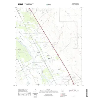
2020 Map of San Miguel
USGS Topo · Published 2020About this map
The Mesilla Valley defines the landscape of this southern New Mexico region, where the Rio Grande is flanked by an intricate network of irrigation systems. The map details the vital water infrastructure supporting local agriculture, including the Mesilla Lateral, Brazito Lateral, and the Chamberino Main Lateral. These canals and drains create a distinct geometric pattern across the valley floor, connecting the small agrarian communities of San Miguel, Mesquite, and Santo Tomas.
Find a feature on this map
119 named features on this map. Tap any name to fly to it.
Don’t see what you’re looking for? This feature index may not catch every label — zoom into the map to look around manually.
Map Details
Editions of this 2020 San Miguel Map
This is the sole edition of this map. No revisions or reprints were ever made.
Other maps of this area

1891 · Las Cruces
USGS Topo · 1:125,000

1893 · Las Cruces
USGS Topo · 1:125,000

1941 · Las Cruces
USGS Topo · 1:62,500

1941 · Organ Peak
USGS Topo · 1:62,500

1943 · La Mesa
USGS Topo · 1:62,500

1943 · Organ Peak
USGS Topo · 1:62,500

1943 · Afton
USGS Topo · 1:62,500

1943 · Las Cruces
USGS Topo · 1:62,500
1955 · Tortugas Mountain
USGS Topo · 1:24,000
1955 · Bishop Cap
USGS Topo · 1:24,000