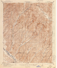
1919 Map of San Miguel
USGS Topo · Published 1941About this map
The Salinas River valley serves as the primary corridor for commerce and settlement in this 1917 survey of the borderlands between Monterey and San Luis Obispo counties. Along the Southern Pacific railroad line, the town of San Miguel stands as a focal point, supported by nearby rural clusters like McKay and Hamilton. The landscape transitions sharply into the Indian Valley and the steep Chokamme Hills, where a remarkably dense network of rural schoolhouses—including Eagle School, Imusdale School, and Independence School—speaks to a distributed ranching community before the consolidation of the mid-twentieth century.
Find a feature on this map
41 named features on this map. Tap any name to fly to it.
Don’t see what you’re looking for? This feature index may not catch every label — zoom into the map to look around manually.
Map Details
Editions of this 1919 San Miguel Map
4 editions found
Other maps of this area

1912 · Coalinga
USGS Topo · 1:125,000

1914 · Cholame
USGS Topo · 1:125,000

1915 · Priest Valley
USGS Topo · 1:125,000

1915 · Cholame
USGS Topo · 1:125,000

1917 · Cholame
USGS Topo · 1:125,000

1919 · San Miguel
USGS Topo · 1:62,500

1919 · Paso Robles
USGS Topo · 1:62,500

1919 · Bradley
USGS Topo · 1:62,500

1919 · Adelaida
USGS Topo · 1:62,500

1932 · Adelaida
USGS Topo · 1:62,500