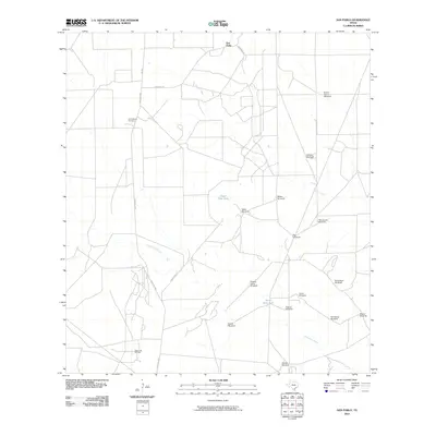
2010 Map of San Pablo
USGS Topo · Published 2010About this map
San Pablo serves as the focal point of this arid South Texas landscape, where life is largely defined by the management of water and mineral resources. The map documents an extensive network of family-named or descriptive windmills, such as Buena Suerte Windmill, Pila Grande Windmill, and Piedras China Windmill, which underscore the region's reliance on groundwater for ranching operations. These features, along with man-made reservoirs like Presa Seca Tank and Upper Field Tank, are essential infrastructure along the drainages of Macho Creek and Santonino Creek.
Find a feature on this map
25 named features on this map. Tap any name to fly to it.
Don’t see what you’re looking for? This feature index may not catch every label — zoom into the map to look around manually.
Map Details
Editions of this 2010 San Pablo Map
This is the sole edition of this map. No revisions or reprints were ever made.
Other maps of this area

1939 · Bruni
USGS Topo · 1:62,500

1956 · Laredo
USGS Topo · 1:250,000

1967 · Hebbronville NW
USGS Topo · 1:24,000

1968 · Parrilla Creek SW
USGS Topo · 1:24,000
1968 · Mills Bennett SW
USGS Topo · 1:24,000

1968 · Mills Bennett
USGS Topo · 1:24,000

1968 · Parrilla Creek NW
USGS Topo · 1:24,000

1968 · Mills Bennett NW
USGS Topo · 1:24,000

1968 · San Pablo
USGS Topo · 1:24,000
1972 · Bruni
USGS Topo · 1:24,000