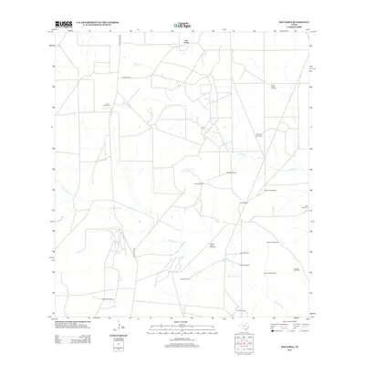
2013 Map of San Pablo
USGS Topo · Published 2013About this map
The settlement of San Pablo serves as the focal point for this section of Webb County, where the dry South Texas landscape is defined by its dependency on scattered water sources and energy extraction. Ranching and oil infrastructure dominate the area, evidenced by the numerous named windmills like Buena Suerte Windmill and Pila Grande Windmill that dot the terrain to provide water for livestock. The West Cole Oil Field signals the industrial character of the region, while the Loma Blanca Cem offers a genealogical touchpoint for local families. Seasonal drainage patterns are traced by the beds of Macho Cr and Santonino Cr, which are supported by engineered water features such as the Upper Field Tank and Presa Seca Tank. This 2013 survey illustrates the continued importance of the sparse road network, including Ranch Road 2050 and Santo Nino Rd, in connecting remote ranch lands.
Find a feature on this map
24 named features on this map. Tap any name to fly to it.
Don’t see what you’re looking for? This feature index may not catch every label — zoom into the map to look around manually.
Map Details
Editions of this 2013 San Pablo Map
This is the sole edition of this map. No revisions or reprints were ever made.
Other maps of this area

1939 · Bruni
USGS Topo · 1:62,500

1956 · Laredo
USGS Topo · 1:250,000

1967 · Hebbronville NW
USGS Topo · 1:24,000

1968 · Parrilla Creek SW
USGS Topo · 1:24,000
1968 · Mills Bennett SW
USGS Topo · 1:24,000

1968 · Mills Bennett
USGS Topo · 1:24,000

1968 · Parrilla Creek NW
USGS Topo · 1:24,000

1968 · Mills Bennett NW
USGS Topo · 1:24,000

1968 · San Pablo
USGS Topo · 1:24,000
1972 · Bruni
USGS Topo · 1:24,000