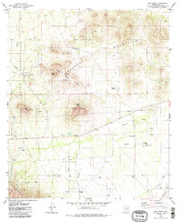
1979 Map of San Pedro
USGS Topo · Published 1985About this map
San Pedro and the high desert terrain of the Roskruge Mountains anchor this late 1970s survey within the Papago Indian Reservation. The landscape is defined by its arid drainage network, where Viopuli Wash and Mendoza Wash converge toward the Brawley Wash in the south. These intermittent watercourses dictate the placement of local infrastructure, including remote outposts like U-Diamond Ranch and Coleman Ranch, which depend on scattered water sources such as Townsend Well and Dill Well.
Find a feature on this map
26 named features on this map. Tap any name to fly to it.
Don’t see what you’re looking for? This feature index may not catch every label — zoom into the map to look around manually.
Map Details
Editions of this 1979 San Pedro Map
3 editions found
Other maps of this area

1920 · Arivaca
USGS Topo · 1:125,000

1934 · Tucson Mountains
USGS Topo · 1:125,000

1934 · Silver Bell
USGS Topo · 1:125,000

1938 · San Vicente
USGS Topo · 1:62,500

1940 · Palo Alto Ranch
USGS Topo · 1:62,500

1941 · San Vicente
USGS Topo · 1:62,500

1941 · Cocoraque Butte
USGS Topo · 1:62,500

1941 · Baboquivari Peak
USGS Topo · 1:62,500

1942 · San Vicente
USGS Topo · 1:62,500

1943 · Cocoraque Butte
USGS Topo · 1:62,500
Featured Places
- Hayhook Ranch, AZ
- San Pedro, Schuk Toak District
- Schuk Toak District, AZ
- Nawt Vaya, Schuk Toak District
- Pima County, AZ