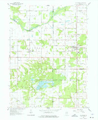
1959 Map of San Pierre
USGS Topo · Published 1977About this map
San Pierre stands at the junction of the Monon and New York Central Railroad lines, serving as a hub for the agricultural and natural landscapes of northern Indiana. The map reveals an extensive network of drainage infrastructure, such as Heimberg Ditch and Davis Ditch, which converted the historic marshlands of the Kankakee River basin into productive farmland and managed wildlife areas. To the south, the Jasper-Pulaski State Game Preserve dominates the terrain, featuring a State Nursery and a Lookout Tower. This 1959 survey records local community anchors including the Township Sch near Tefft, the Little Company of Mary Hospital, and All Saints Cem, reflecting the social and civic fabric of Starke and Jasper counties before later 20th-century consolidations.
Find a feature on this map
45 named features on this map. Tap any name to fly to it.
Don’t see what you’re looking for? This feature index may not catch every label — zoom into the map to look around manually.
Map Details
Editions of this 1959 San Pierre Map
2 editions found
Other maps of this area

1953 · Kouts
USGS Topo · 1:24,000

1953 · Chicago
USGS Topo · 1:250,000

1957 · Chicago
USGS Topo · 1:250,000

1957 · Wheatfield
USGS Topo · 1:24,000

1958 · La Crosse
USGS Topo · 1:24,000

1959 · English Lake
USGS Topo · 1:24,000

1959 · North Judson
USGS Topo · 1:24,000

1959 · San Pierre
USGS Topo · 1:24,000

1962 · Medaryville
USGS Topo · 1:24,000

1962 · Gifford
USGS Topo · 1:24,000