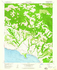
1958 Map of San Simeon
USGS Topo · Published 1960About this map
Hearst Castle stands as the prominent landmark of this coastal landscape, situated within the Hearst San Simeon State Historical Monument just before the 1960s. The map illustrates the grand estate's relationship with the surrounding Hearst Ranch and the Pacific coastline, where San Simeon Bay and San Simeon Point provide natural shelter. This 1958 field-checked survey documents a transition from the historic coastal village at San Simeon to the high ridges of the Santa Lucia Range, marked by peaks like Garrity Peak and drainage systems including Arroyo de la Cruz.
Find a feature on this map
41 named features on this map. Tap any name to fly to it.
Don’t see what you’re looking for? This feature index may not catch every label — zoom into the map to look around manually.
Map Details
Editions of this 1958 San Simeon Map
3 editions found
Other maps of this area

1919 · Bryson
USGS Topo · 1:62,500

1919 · Piedras Blancas
USGS Topo · 1:62,500

1919 · San Simeon
USGS Topo · 1:62,500

1921 · Cape San Martin
USGS Topo · 1:62,500

1927 · Piedras Blancas
USGS Topo · 1:62,500

1937 · San Simeon
USGS Topo · 1:62,500

1941 · Cape San Martin
USGS Topo · 1:62,500

1941 · Bryson
USGS Topo · 1:62,500

1942 · Bryson
USGS Topo · 1:62,500

1942 · Cape San Martin
USGS Topo · 1:62,500