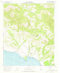
1958 Map of San Simeon
USGS Topo · Published 1973About this map
Hearst Castle and the sprawling Hearst Ranch dominate this coastal landscape as it appeared in the late 1950s. The map captures the interface between the Pacific Ocean and the steep terrain of Piedra Blanca, where the Hearst San Simeon State Historical Monument was already a designated landmark. Along the coast, San Simeon sits sheltered by San Simeon Point on the edge of San Simeon Bay, with the Cabrillo Highway serving as the primary transit corridor. Inland, the map reveals a network of canyons and peaks like Garrity Peak and Lone Tree Hill, interspersed with remote outposts such as Burnett Camp and Chileno Camp. The drainage patterns of Arroyo de la Cruz and Pico Creek illustrate the watershed that feeds into the bay, while numerous springs and a private heliport suggest the developed yet secluded nature of the Hearst estate during this era.
Find a feature on this map
37 named features on this map. Tap any name to fly to it.
Don’t see what you’re looking for? This feature index may not catch every label — zoom into the map to look around manually.
Map Details
Editions of this 1958 San Simeon Map
3 editions found
Other maps of this area

1919 · Bryson
USGS Topo · 1:62,500

1919 · Piedras Blancas
USGS Topo · 1:62,500

1919 · San Simeon
USGS Topo · 1:62,500

1921 · Cape San Martin
USGS Topo · 1:62,500

1927 · Piedras Blancas
USGS Topo · 1:62,500

1937 · San Simeon
USGS Topo · 1:62,500

1941 · Cape San Martin
USGS Topo · 1:62,500

1941 · Bryson
USGS Topo · 1:62,500

1942 · Bryson
USGS Topo · 1:62,500

1942 · Cape San Martin
USGS Topo · 1:62,500