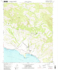
1958 Map of San Simeon
USGS Topo · Published 1988About this map
Hearst Castle stands as the central landmark of this coastal landscape, situated within the Hearst San Simeon State Historical Monument and overlooking the Pacific. The map details the transition from the shorelines of San Simeon Bay and San Simeon Point to the dramatic elevations of the Santa Lucia Range. Inland, the extensive Hearst Ranch is supported by its own infrastructure, including the Hearst Airport and various reservoirs. The terrain is deeply incised by drainages such as Arroyo de la Cruz and Arroyo Laguna, which flow toward the Cabrillo Highway. Further north, more isolated sites like Burnett Camp and Chileno Camp reflect the ranching and resource-based activity of the era. Genealogists and local historians can find subtle details like a solitary Grave located near Oak Knoll and the various survey markers and heliports used for land management.
Find a feature on this map
40 named features on this map. Tap any name to fly to it.
Don’t see what you’re looking for? This feature index may not catch every label — zoom into the map to look around manually.
Map Details
Editions of this 1958 San Simeon Map
3 editions found
Other maps of this area

1919 · Bryson
USGS Topo · 1:62,500

1919 · Piedras Blancas
USGS Topo · 1:62,500

1919 · San Simeon
USGS Topo · 1:62,500

1921 · Cape San Martin
USGS Topo · 1:62,500

1927 · Piedras Blancas
USGS Topo · 1:62,500

1937 · San Simeon
USGS Topo · 1:62,500

1941 · Cape San Martin
USGS Topo · 1:62,500

1941 · Bryson
USGS Topo · 1:62,500

1942 · Bryson
USGS Topo · 1:62,500

1942 · Cape San Martin
USGS Topo · 1:62,500